|
|
|
Southern Lebanon. Green indicates Israeli occupied town; red IDF warned towns of operations, orange recent clashes. Click map to view. |

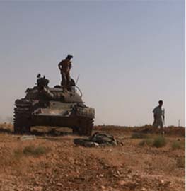
The Israeli Defense Force’s Golani Brigade has taken the town of Bint Jubayl, Hezbollah’s southern command center, and is moving towards the town of Aytarun, another of the towns the IDF has warned the Lebanese citizens to evacuate due to upcoming operations in the area. The Golani Brigade states it has killed up to 50 Hezbollah fighters, and indicates over 100 may still be holed up in Bint Jubayl. Also, the IDF reports Abu Jaafar, Hezbollah’s “commander of the ‘central sector,'” has been killed in combat.
Further equipment of Iranian origin has been confirmed. “Electronic surveillance equipment, weapons and communication devices made in Iran,” have been uncovered Bint Jubayl, according to IDF Brigadier General Gal Hirsch. “Senior Lebanese political sources” indicate “between six and nine” members of the Iranian Revolutionary Guard Corps have been killed in Lebanon are being flown home.
A New Buffer Zone (continued)?
We discussed the likelihood of the IDF creating a buffer zone on July 17th. As the IDF continues to methodically engage Hezbollah on the border, the wider picture of the Israeli strategy begins to coalesce. “Israel’s ground offensive will not go beyond South Lebanon,” states Lieutenant Colonel Hemi Lini, a commander on the Lebanese border, “We have no intention of extending our operation more than 70 kilometers north of our border with Lebanon.”
Defense Minister Amir Peretz, who previously stated he had no interest in occupying southern Lebanon, indicated today that a buffer zone on the southern border would be created and secured by the IDF until “a multinational force with an enforcement capability” was deployed. “Javier Solana, the EU foreign and security affairs chief, will propose at a conference of foreign ministers in Rome on Wednesday the establishment of a rapid reaction force ideally built around French, German and Spanish troop, supplemented by forces from Turkey, the Netherlands, Canada and Arab states such as Egypt and Saudi Arabia,” reports The Associated Press. A force of 20,000 is envisioned, however based on the stress the Afghanistan deployments has placed on NATO
Diplomatic pressure for Israel to halt operations and accept a cease fire will only increase as time goes by. The United States can deflect the pressure for only so long. And Hezbollah gains in stature each day as it stands up to the vaunted Israeli Army. Time is not on Israel’s side.
Operational Possibilities
Lt. Col. Lini also indicates operations will continue on the Lebanese border are “Israeli troops are planning to enclose additional border villages.” Many of the towns the IDF ordered evacuated (red on the map) have yet to receive the attention of the IDF. The move into Aytarun will likely be followed by an assault on Bilda, then followed by a push northward, possibly all the way to the Litani River.
A report indicates Israeli troops are massing at the Israeli border town of Metulla, which lies a few kilometer from the bend in the Litani River, just before it turns northward. The IDF can segment the region south of the Litani by punching through the central sector north of Bint Jubayl, as well as driving northeast from Metulla to the Litani River and north from Marwahin. This would also put the IDF in the position to push north into the Bekaa (it should be noted the Damascus-Beirut Road is about 60 kilometers from the Israeli border, within the 70 kilometer range Lt. Col. Lini indicated was the outer operational limit).
The IDF can use the Litani as a natural barrier, place troops north of the river via the ground push, air assault operations, amphibious operations, or some combination of the three options. The IDF can drop the remaining bridges (except for the bridges needed for the IDF’s resupply). The IDF can limit the flow of traffic across the river and interdict Hezbollah’s resupply to the region. The rest of the region would need to be cleared, which would be costly in casualties for the IDF if the past fighting at Maroun al-Ras and Bint Jubayl are any indication. Another possibility would be to clear or bypass towns, but not occupy them, and patrol the region via air and other intelligence assets (this works better in theory than in practice.)
This would create a buffer zone of about 20-30 kilometers, which would limit the usability of Hezbollah’s shorter range missiles such as the Katushas, Raads and Fajrs. But Hezbollah is launching missiles from as far north as Beirut, about 120 kilometers away (see the report from Karim, the Counterterrorism Blog’s special correspondent in Beirut.) The Israeli Air Force can attempt to take out the targets via air, but the past two weeks have had little effect on Hezbollah’s ability to continually hit Israeli towns and cities, including Haifa. Hezbollah has consistently launch about 100 missile strikes a day into Israel, despite the IAF’s air campaign in Lebanon.
While the IAF claims to have degraded Hezbollah’s capabilities by over 50%, western military sources are skeptical of the claims. And as Hezbollah is bought, paid for and controlled by Iran, a resupply of Hezbollah’s lost military assets would begin immediately after any cease-fire took place. Israel is going to have to occupy some land and push into Bekaa if it wishes to sufficiently degrade Hezbollah’s military capabilities and deal a political defeat to the Army of God.


6 Comments
Lebanon Maps And Satellite Photos
Between the job I’ve got and the job I’m looking for, I haven’t had much time to follow the news and post. But I did take some time today to look for some new maps showing Bint Jbeil, which the IDF claims it has successfully taken.
MidEast War: XLIII
July 25, 2006 18:00 PDT Frequent updates. Scroll. Previous coverage @ right. Links to Lebanese and Israeli bloggers covering the conflict are @ Truth Laid Bear, plus a map view of bloggers in war zone. Map of war zone here….
Haveil havalim daily edition 07/25/2006
In depth: I was going to write about this even before the airstrike that killed the UN Observers yesterday. Of course news reports are going to quote Kofi Annan who will be understandably upset and since it was his men who were killed. But when dealing…
IDF Operations; Buffer Zones; Operational Possibilities
Courtesy of the Counterterrorism Blog:
By Bill Roggio
Southern Lebanon. Green indicates Israeli occupied town; red IDF warned towns of operations, orange recent clashes. Click map to view.
The Israeli Defense Force’s Golani Brigade has take…
A Born Necessity
Bill Roggio elucidates the buffer zone theory:
A report indicates Israeli troops are massing at the Israeli border town of Metulla, which lies a few kilometer from the bend in the Litani River, just before it turns northward. The IDF can seg…
Capture of Bint Jubayl