Created by Bill Roggio
Interactive
Click here to view the interactive
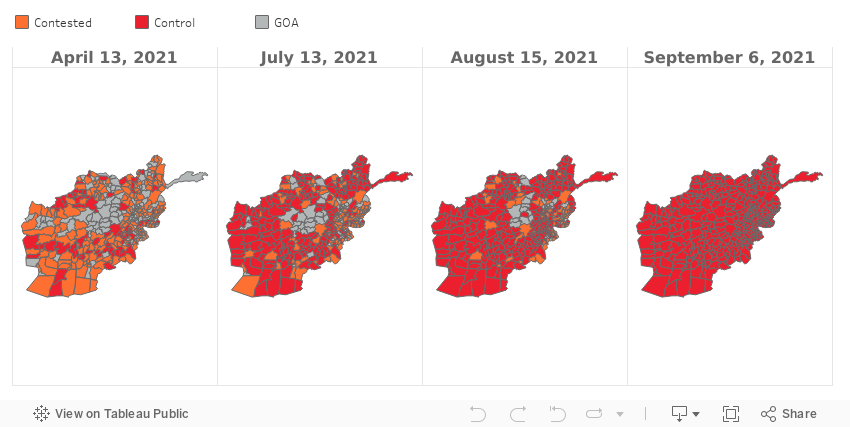
Weekly time lapse video of the Taliban’s Advance | Apr 13 to Sept 6, 2021
Semi-Yearly time lapse of Afghanistan’s districts | Nov 2017 to Sept 6, 2021
Description: For nearly two decades, the government of Afghanistan – with the help of U.S. and coalition forces – battled for control of the country against the ever-present Afghan Taliban. FDD’s Long War Journal has tracked the Taliban’s attempts to gain control of territory since NATO ended its military mission in Afghanistan and switched to an “advise and assist” role in June 2014. Districts have been taken and retaken (by both sides), only to be lost shortly thereafter, decreasing the security situation. Since the U.S. drawdown of peak forces in 2011, the Taliban has unquestionably been resurgent.
Time lapse of Afghanistan’s falling provinces | Apr 13 to Sept 6, 2021
Map of Afghanistan’s districts
Methodology: The primary data and research behind this assessment are based on open-source information, such as press reports and information provided by government agencies and the Taliban. This is a living and breathing map that LWJ frequently updates as verifiable research is conducted to support control changes.
An “Unconfirmed” district colored orange has some level of claim-of-control made by the Taliban, but either has not yet been — or cannot be— independently verified by LWJ research.
A “Contested” district may mean that the government is in control of the district center or buildings within the district center, or a base, but little else, while the Taliban controls large areas or all of the areas outside of the district center. Or, the Taliban may control several villages, mines and other resources, runs prisons in the district, or administers areas of the district.
A “Controlled” district may mean the Taliban is openly administering a district, providing services and security, and also running the local courts. LWJ may assess a district Taliban controlled if the district center frequently exchanges hands and/or the government only controls a few buildings or villages in the district.
Beginning in Jan. 2018, LWJ incorporated district-level data provided by the Special Investigator General for Afghanistan Reconstruction (SIGAR), which is based on assessments by Resolute Support, NATO’s command in Afghanistan. This information was helpful in filling the gaps in reporting on districts where there was little open source information (note: reporting on more opaque districts has improved since mid-2019).
However, Resolute Support has continually downplayed the Taliban’s level of control as well as contested districts in its reporting. For an explanation and analysis of why, see LWJ report: U.S. military assessment of Taliban control of Afghan districts is flawed.
In April 2019, Resolute Support stopped producing the assessment. The U.S. Department of Defense stated that negotiations with the Taliban, and not the status of Afghanistan’s districts, was the real metric of progress. For a detailed explanation of this, see LWJ report: US military ends reporting on security situation in Afghanistan’s districts. Some districts may retain the Resolute Support district assessment. If there are no indications that the status of the district has changed since the time of the Resolute Support’s Jan. 2019, report, that assessment will remain and will be noted in the comments.
Population control: Due to internal displacement, flight from the country, and a lack of accurate census reporting in the active combat zones, the population numbers are disputed and subject to change. The current projection is based on data from the CIA World Factbook’s 2018 evaluation of Afghanistan. The population estimates should be used as a guide only.