|
|
|
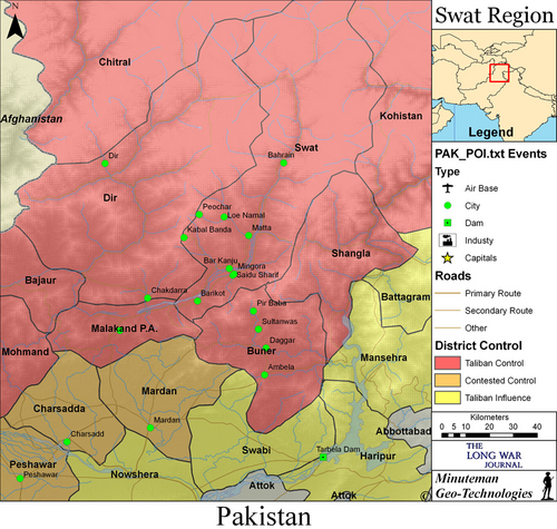
Click map for full view. Taliban presence, by district and tribal agency, in the Swat region. Information on Taliban presence obtained from open source and derived by The Long War Journal based on the presence of Taliban shadow governments, levels of fighting, and reports from the region. Map created by Bill Raymond for The Long War Journal. Last updated: May 12, 2009. |
The Pakistani military is still facing tough resistance from Taliban forces in Swat and Buner as the operation in the Malakand Division enters its fourth week.
The operation, known as Rah-e-Haq 4, is the military’s fourth attempt to clear the Taliban from the Swat region since the fall of 2007. The prior operations failed to eject the Taliban and led to peace deals that put the Taliban in control of the district.
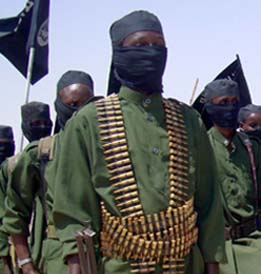
The Pakistani Army has thrown more than 15,000 troops into the fight against an estimated 5,000 to 7,000 Taliban fighters in Swat. According to military reports, the number of Taliban fighters killed is fast approaching 1,200.
But US military and intelligence officials tracking the operation described the Taliban body count as “wildly exaggerated” and “fantastic.” The Pakistani Army is mixing civilian and Taliban casualties, and the real number of Taliban killed is thought to be between 300 and 500, a senior US military intelligence official told The Long War Journal.
In Swat, the Pakistani Army is still attempting to reach main city of Mingora. The military has launched a three-pronged offensive with the aim of converging on the city.
Despite Army claims last week that Mingora was surrounded by Pakistani troops, recent reports indicate the Army is still engaged in heavy fighting in the towns and villages outside the city. The Taliban has mined the roads and is conducting complex ambushes, according to reports.
The Army is reported to be clearing the towns of Kanju and Matta. Yesterday one officer and one soldier were reported killed during fighting in Matta, while 14 Taliban fighters and two soldiers were killed outside of Kanju.
Interior Minister Rehman Malik claimed the Khawazakhela region in Swat has been cleared of Taliban fighters.
The military is still attempting to secure the Peochar Valley, the headquarters of the Swat Taliban. Newly trained commandos from Pakistan’s paramilitary Frontier Corps were air-assaulted into Peochar more than a week ago, and are still engaged in heavy fighting. Two Taliban have been reported killed in the operation.
An unconfirmed report in The News indicates that four commandos from Pakistan’s elite Special Service Group, including a captain named Najam Riaz, were captured in Swat and then killed by the Taliban as they attempted to escape. The military has not reported any SSG commandos as killed or captured during the operation.
As for the neighboring district of Buner, Malik claimed yesterday the district has been fully cleared and encouraged civilians to return to their homes. “Buner and Dir are under our control, and the operation-affected people can return to their areas, and we shall provide them full security,” Malik said.
Military reports on the situations in Dir and Buner contradict Malik’s claim, however.
Major General Athar Abbas, the chief spokesman for the military, reported that the town of Pir Baba in Buner is still contested, and Sultanwas was just cleared today. He reported that heavy fighting in Sultanwas today resulted in the deaths of 80 Taliban fighters and one soldier, and said the town was cleared of Taliban fighters.
“Sultanwas was the main stronghold of terrorist-miscreants in Buner, where they have made concrete underground bunkers and ammunition dumps,” Abbas said in a press briefing.
With regard to the district of Dir, the military stated the town of Madain will be cleared within three days. The military claimed Dir was cleared one day after the operation began on April 26, and has said Madain was secured several times since then. In the latest round of fighting in Dir, five Taliban fighters are reported to have been killed.
The military said 250 Taliban fighters and 30 Pakistani troops have been killed during fighting in Dir since the operation began.
Background on the Malakand Accord and fighting in Swat
The fighting in Swat, Dir, Buner, and Shangla broke out after a peace agreement with the Taliban failed. The agreement, known as the Malakand Accord, placed the Malakand Division and the district of Kohistan under the control of the Taliban. The Malakand Division is comprised of the districts of Malakand, Swat, Shangla, Buner, Dir, and Chitral. The Malakand Division and the neighboring Kohistan district together encompass nearly one-third of the Northwest Frontier Province.
The government signed the Malakand Accord with Taliban front man Sufi Mohammed, Fazlullah’s father-in-law, on February 16 after two years of fighting that put the Taliban in control of the district. During those two years, the military was defeated three separate times while attempting to wrest control from the Taliban. Each defeat put the Taliban in greater control of the district.
The peace agreement called for the end of military operations in Swat, the end of Taliban operations, and the imposition of sharia, or Islamic law, in the Malakand Division.
But the Taliban violated the agreement immediately after signing it, and proceeded to attack security forces and conduct armed patrols. The military remained silent while the government approved the Taliban’s demand for sharia throughout Malakand.
The government ordered a military offensive in Dir and Buner after enormous pressure from the US and other Western governments to stem the Taliban tide pushing toward central Pakistan. The Taliban advanced from Swat into Buner in early April and took over the district in eight days. The move into Buner has put the Taliban within 60 miles of Islamabad and close to several nuclear facilities and the vital Tarbela Dam. The Taliban also have moved into Mansehra and established bases and a training camp in the region.
Pakistani government and military officials have dismissed the Taliban threat to Islamabad and the country’s nuclear facilities, but at the end of April, the local Islamabad government ordered troops to deploy in the Margala hills just north of the city to block a Taliban advance, while the Haripur government beefed up security at the Tarbela Dam.


10 Comments
“Islamabad government ordered troops to deploy in the Margala hills just north of the city to block a Taliban advance”
I am resident of Islamabad, hiking over margalla hills is included in one of our daily routines. I never saw any troops out there…. Please do confirm on ground, after making such statements. Here life continues same as it was. Thinking taliban or any one else as a threat to our nation or nuclear facilities is not less than a joke.
The town of Khawazakhela is 3.5 km directly east of Matta across the Swat river. It is the entry point into the Swat valley from the east, via the Shangla Pass. There is a bridge across the Swat river 2km north of Khawazakhela. The Pakistani army moved down the Shangla Pass through Khawazakhela and across the bridge to get to the Matta area on the west side of the Swat river.
In fact the numbers don’t reflect the stories told by eye witnesses all over Pakistan. First it would take they claim, billions, lets go with that number even though it is extremely low, of dollars to now fis what is happening in Pakistan, and it is once again destablized. Only further pressing rumors of negotiations for nuclear weapons in India. The facts are that the people don’t fear the Taliban like India. The deal has been in the works for years now. Musharraf had a way with the people of India but became very unpopular in his own country, the fact that it was supported by a bill in congress asking to reinterrogate AQ Kahn at this point in time is a little, demystifying if you ask me. Unfortunantely the whole thing stinks of political BS.
But it is old news to even say.
If this is Pakistani Army and not Frontier Corps, it could be a positive sign that GovPak is playing hardball this time. We’ll have to see.
I believe Takhaband village is 1.5 km west of Ingaroderai.
These are along the South side of the Swat river. They are part of Mingora’s north-west suburbs.
Takhaband Village 34° 46′ 44″ N, 72° 19′ 19″ E
Ingaroderai Village 34°47′ 2″ N, 72°20’18” E
Ingaroderai is 1 km southwest of the Kanju bridge. Both villages lie along a river road called the Takhtband Bypass road which passes to the north of the main road approaching Mingora. The main road passes through populated villages along the foothills.
It does appear that the Pakistani army is flanking the populated villages and pressing east along the Takhtband road toward the Kanju bridge where they can link up with the smaller force pressing south from at airport.
As always, if someone suspects my information to be wrong, let me know. The names of some of these small villages are hard to track down and the sourcing can be a bit iffy.
Nice report by LWJ, with map showing key towns.
Military’s approach seems good in clearing populous Mingora later. Good news from Buner and Dir too.
Bill and other readers here,
Seldom will you find a better report on the politics behind the insurgency and duplicity of Pak Army. Written by Ahmed Rashid. Link : http://www.nybooks.com/articles/22730
The Thunder Run has linked to this post in the blog post From the Front: 05/21/2009 News and Personal dispatches from the front and the home front.
The politics may have a history of duplicity, but we do need to acknowledge that there is a very real fight going on. The Pakistani army is slowly pushing its way into a heavy fight. Whatever issues we may have with how this is being done, I don’t doubt that this is a real fight.
Accounts from wounded souldiers.
http://www.dawn.com/wps/wcm/connect/dawn-content-library/dawn/news/pakistan/07-I-was-standing-in-front-of-my-trench-when-I-was-shot-ha-03
The locals in far northern Kalam have fought off Taliban incursions into their area.
http://www.dawn.com/wps/wcm/connect/dawn-content-library/dawn/news/pakistan/provinces/04-armed-locals-foil-taliban-attempt-to-enter-kalam-qs-04
Kalam 35°28’40” N, 72°35’28″E
Note that Kalam is not ethnically Pashtun but is Kohistani (Gawri)
I believe I have located the Banai Banda Ziarat area south-east of Mingora. There is a mountain with a flattened top labeled (Banj Sar) on Google earth. The last good back-road from Buner province into Mingora winds through a pass 2km east of this mountain. 34°41’04″N, 72°28’46″E
I recently started using this link to find villages in Pakistan’s North-West Frontier.
http://www.worldcitydb.com/north-west_frontier_in_pakistan_state.aspx
This is another resource I have been using recently
http://www.maplandia.com/pakistan/n-w-f-p/