The Pakistani Army and Air Force hit the Taliban again in a region considered an extremist stronghold in the northwest.
Pakistani fighter-bombers hit Taliban positions in the Arakzai tribal agency in a region bordering Khyber. Eleven Islamic extremists, most of whom were described as “foreigners,” a term used to describe al Qaeda operatives, were killed in the attack and seven more were reported wounded.
The airstrike in Arakzai is the second there this week. On Nov. 17, Pakistani strike aircraft, Army attack helicopters, and artillery batteries struck enemy hideouts and supply depots in the Taliban-controlled tribal agency. Thirty Taliban fighters were reported killed. The military also pounded 11 Taliban camps in Arakzai in September.
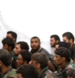
Hakeemullah Mehsud, the leader of the Movement of the Taliban in Pakistan, an alliance of several Taliban groups operating in the northwest, commanded Taliban forces in Arakzai before taking control of the group in August. Hakeemullah declared sharia, or Islamic law, in Arakzai in December 2008. Now Taliban fighters fleeing the operation in South Waziristan are regrouping in Arakzai as well as in Khyber and North and South Waziristan.
Arakzai hosts several Taliban extremist groups, including the Fedayeen-e-Islam, the Lashkar-i-Jhangvi, the Commander Tariq Group, the Ghazi Force, the Omar Group, and the Abdullah Azzam Brigade. These groups have taken credit for suicide bombings and armed attacks in Islamabad, Peshawar, and Lahore.
The military and the Taliban have also clashed in neighboring tribal agencies and settled districts over the past day. In Hangu, seven Taliban fighters and a commander were captured after they ambushed a military convoy. The ambush took place in a region bordering the North Waziristan and Kurram tribal agencies; this region has been a known transit area and safe haven for Taliban forces. Just weeks ago, the military destroyed a section of road there in an attempt to disrupt Taliban movement in the area.
In the Bara region in Khyber, the Army claimed to have killed eight Taliban fighters in artillery strikes after the Taliban killed a Frontier Corps official in a roadside bombing attack in the region. Seven suspected Taliban fighters were also detained in follow-up raids. The Taliban also bombed a school in Bara in Khyber; it was the fourth school in Bara to be destroyed this week.
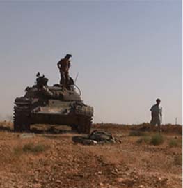
In South Waziristan, 14 Taliban fighters and six soldiers have been killed over the past 24 hours as the military continues its advance through the Taliban heartland. The military recently claimed to have ejected the Taliban from the major towns and villages and said the remaining fighters are in the mountains and forests of the region.
The military has claimed that more than 550 Taliban fighters and 76 soldiers have been killed since the operation commenced on Oct. 17. More than 10,000 Taliban fighters backed by an estimated 1,500 hard core al Qaeda and Central Asian fighters were thought to be in the region. The Taliban now claim that they have conducted a tactical retreat and will wage an insurgency as the winter snows settle into the area.


12 Comments
Bill i didn’t know where to thank you for uploading that video of Abdul Rahim Wardak the afghan defense minister so i thought i’d post it here–thank you. Brief as it is it gives a little linsight of local flavor.
Is it possible to have comments added to them too? It’ll also make it more efficient if comments are uplinked faster for the conversation to be more cohesive, but i know you have your hands full and wish for you that your coffers reflect that. RESPECT!
South Waziristan Update.
Over the last two weeks the heaviest fighting in South Waziristan has been north of Sararogha up to the villages surrounding Janata. The Pakistani army mentions clearing operations of Janata three days ago. So far there has been no mention of the many villages just to the north of Janata. This is getting very close to the border with North Waziristan with the village of Mir Khoni just across the border.
List of villages between Sararogha and Janata.
Sararogha 32.52 N, 70.02 E
Ahmadwam 32.54 N, 70.01 E
Bangiwala 32.546 N, 69.994 E
Madikai 32.548 N, 70.016 E
Tsappara 32.54 N, 70.03 E
Shavzai 32.561 N, 70.011 E
Pamonkai Raghzai 32.556 N, 70.043 E
Maraki Pungai 32.574 N, 69.999 E
Adira Mela 32.573 N, 70.019 E
Khawasai 32.577N, 70.025 E
Kung Mela 32.58 N, 70.023 E
Kazhikai 32.581 N, 70.038 E
Duani Kili 32.583 N, 70.00 E
Hisar Ragha 32.585 N, 70.02 E
Kaskai 32.593 N, 69.990 E
Janata 32.60 N, 70.01 E
Those of you attempting to follow the ISPR news releases have probably figured out by now that they are VERY frequently messed up, reporting action in the wrong regions of South Waziristan and occasionally getting things messed up with action in other districts. I wish they would get a map and check their news releases.
Thanks for the coordinates Neo.
Have you collected all of your locations together and put them on a web site for easy access?
I also noticed recently that Google Maps doesn’t have all these location (and does accept additions).
Unless they’re just spouting off names to sound good to alleviatet he concerns of the people….
Thanks to both Bill and Neo who make it at least somewhat possible to follow events in this area.
Given the critical nature of this effort in Pakistan to our own efforts in Afghanistan and the impending decision on American involvement, it seems more important than ever that the public have some clue.
“Unless they’re just spouting off names to sound good to alleviate he concerns of the people….”
neo and kp,
Try Google Earth instead of Google Maps. Google Earth is designed so you can create files of additional data to pass around.
My 2 cents.
I’ve been thinking about doing just that, but my first attempt crashed. I’ll try again some time.
Razmak – Makeen Axis
During the first three weeks progress from the base at Razmak toward Tauda China and Makeen was very slow and the Army only controlled the immediate area around the Razmak-Makeen road. The Makeen area was heavily defended. By the third week the army pushing south from Razmak had only taken Makeen and the adjacent villages of Tauda China Khula and Sir Rugh to the south-east of Makeen.
Elsewhere, the initial thrust of the Pakistani army was against Kaniguram and the Ladha fort in the Badder Valley to the south. It was only after the army took the Ladha area just to the south of the area that progress picked up. The villages and ridges to the west of Makeen were captured quickly over the next ten days, seemingly without a huge amount of resistance. To this point no one has made an explanation of what happened, but the sudden capture of the Ladha area may have forced Taliban forces in this area to quickly escape, rather than be cut off to the east, and pressed up against the high mountains to the west.
During the last week the Pakistani Army has completed it’s expansion to completely fill the Razmak-Makeen Plain and has moved to control the mountain ridges above the western rim of the plain.
Just today it also appears that Pakistani forces are starting to capture a few positions in the mountains 10-12 km to the west of Razmak. I’ll get back to that as I get a better picture of what is going on.
Razmak 32.69 N, 69.83 E
Newal 32.70 N, 69.855 E
Newal Khula 32.701 N, 69.848 E
Shora Kas 32.691 N, 69.822 E
Shanderai 32.674 N, 69.841 E
Shami Khela 32.676 N, 69.812 E
Tauda China 32.64 N, 69.836 E
Warogh Tangi 32.638 N, 69.818 E
Kam Narakai 32.631 N, 69.814 E
Bashka 32.633 N, 69.806 E
Bazam 32.627 N, 69.81 E
Imar Khel Zangai 32.622 N, 69.813 E
Tora Tizha 32.618 N, 69.803 E
Kot Band Khel 32.62 N, 69.817 E
Wuchoba 32.619 N, 69.827 E
Mian Nur Khel 32.628 N, 69.824 E
Bahadur Khel 32.623 N, 69.831 E
Makeen 32.62 N, 69.84 E
Sir Rugh 32.614 N, 69.839 E
Tauda China Khula 32.614 N, 69.844 E
Marobi Raghza 32.601 N, 69.868 E
Bibi Raghzai 32.594 N, 69.879 E
Shankai Sar 32.706 N, 69.813 E (mountain)
Tabai Sar 32.701 N, 69.792 E (mountain)
Khandai Sar 32.690 N, 69.803 E (mountain)
Litta Sar 32.642 N, 69.807 E (mountain)
Blanki Sar 32.65 N, 69.796 E (mountain)
(Sar = Mountain Narai = Pass)
Notes:
The base at Razmak has a paved air strip and could be reinforced/supplied from just about anywhere in Pakistan, although there are going to be limits on capacity.
Please note the Tauda China is the river that flows through the area. It meets the Badder river at Dwa Toi(Zhawar) 32.585 N, 69.90 E than flows east past Sararogha. It doesn’t look like the Pakistani army has yet moved to capture the 20 km road between Makeen and Sararogha along the river, although mention is given of some action against the large village of Shahbozai about half way between.
I’m still wondering what the Pakistanis are going to do with the members of the Taliban or al Qaeda they capture? Are they just killing them, do we ever hear from them again, or are they released so that they can go back and start fighting the Pakistani Army all over again? I doubt that the Pakistanis would want to keep them in prison for any length of time and I’m sure they would be worried that any captured Taliban or al Qaeda members would try to convert the rest of the prison population. So what do they do with them? The number of captured Taliban and al Qaeda members must be growing since this war heated up, so I would imagine that it’s a growing problem, right? Yet you hear nothing about it. Strange.
Anybody know what the Pakistanis are doing with the Prisoners they are taking from the Taliban and al Qaeda? Are they killing them after they interrogate them, or are they just putting them into a civilian prisoner population? I doubt that the Pakistanis would want the Taliban or al Qaeda prisoners trying to convert the other inmates in a civilian prison, so what are they doing with them? Are the Pakistanis isolating them in a special Prisoner of War camp? Strange you never hear anything about this.
Ladha Area
This has become old news by now, since it happened three weeks ago. After Kanigurram fell the Pakistani army pursued Taliban forces deep into the Badder valley. There was a sharp fight at the Old British Ladha Fort and villages just to the north of Ladha. This was the last large scale battle in this area as the Taliban may have been trying to cover their retreat. The Pakistani Army has voice genuine surprise that they where able to strike so deep as early as they did. Taliban resistance across the area seemed to quickly give out once the Army took Ladha.
Once in the Ladha area the Pakistani army quickly spread out to the north and west over the following week. They took Satta and Takrai Sar hill overlooking the juncture of the Badder and Tauda China rivers. They linked up with forces coming down from the Razmak – Makeen area. They also pushed west toward the high mountains, quickly getting as far as Narakai and Gowak before stopping to consolidate their gains.
Just the last few days the army is pushing again to the west at Spin Kot, toward the high mountain passes that exit the area.
Old Ladha Fort 32.565 N, 69.83 E
Ladha Bridge 32.562 N, 69.835 E
Ladha 32.58 N, 69.83 E
Bangal Khel 32.575 N, 69.83 E
Shwawan Mela 32.577 N, 69.841 E
Abak 32.569 N, 69.841 E
Lata 32.573 N, 69.852 E
Satta 32.576 N, 69.857 E
Takrai Sar 32.587 N, 69.866 E (Large hill overlooking Satta)
Pungai 32.569 N, 69.808 E
Narakai 32.573 N, 69.79 E
Zhawar 32.575 N, 69.788 E
Gidarai 32.585 N, 69.777 E
Siga 32.583 N, 69.815 E
Langi Khel 32.579 N, 69.832 E
Tatai 32.583 N, 69.827 E
Sultana 32.588 N, 69.812 E
Manzai 32.586 N, 69.802 E
Ghowak 32.589 N, 69.801 E
Spin Kot 32.599 N, 69.793 E
Note: I hope to give all the major areas a once over before attempting to transfer these coordinates to Google Earth format.